Biscayne Bay is Miami’s shallow backyard: a long, bright lagoon between the mainland and the barrier islands that runs from downtown south to the top of the Florida Keys. Most of it is far shallower than people expect. Published figures put the average depth of the bay at about 6 ft (1.8 m), with a natural maximum of around 13 ft (4 m) outside dredged channels. That makes it one of the best urban paddling and skiff-fishing waters in the country, and also one of the easiest places to run aground. This guide explains the main zones, from the Key Biscayne sandbar and Stiltsville down to Elliott Key in Biscayne National Park. The satellite depth map for each cell is updated regularly.
What the bottom looks like
- Northern bay (Rickenbacker Causeway to Key Biscayne): sand and grass flats with dredged channels, spoil islands and heavy boat traffic. The Nixon sandbar off the west side of Key Biscayne is a firm sand shelf that fills with anchored boats on weekends.
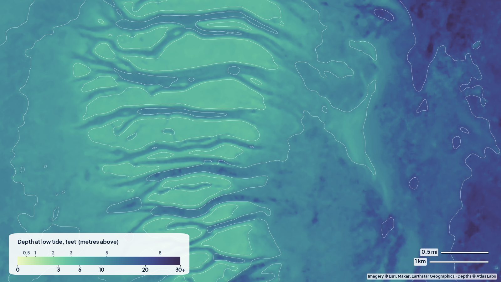
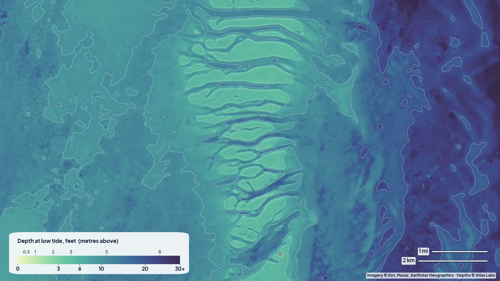
- Safety Valve and Stiltsville: south of Cape Florida, the bay drains to the ocean across a wide field of shallow sand banks and tidal channels called the Safety Valve. Stiltsville’s houses stand on these flats, in water that is often only a few feet deep at low tide.
- Central bay (Featherbed Banks to Black Point): open grass flats and soft bottom, broken by the shallow Featherbed Banks and the deeper Intracoastal channel.
- Southern bay and Elliott Key: turtle grass flats on the bay side of the key, a sandy beach and hard bottom on the ocean side, then patch reefs inside the main reef tract.
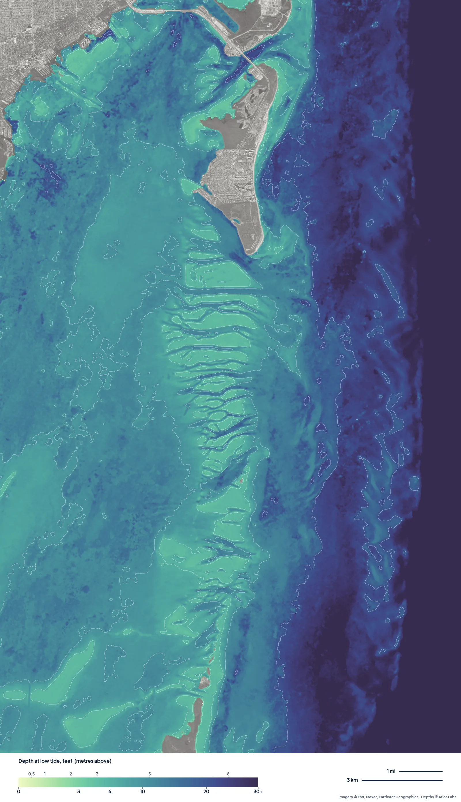
The real depth map of south Biscayne Bay at low tide. The comb of pale ridges and blue cuts in the middle is the Safety Valve, where the bay drains to the ocean; most of the open bay reads roughly 6 to 15 ft. Tap any spot on the live map for a number.
Approximate depth by zone
Typical ranges only; depth changes with tide and wind, so check the live map.
- Nixon sandbar (Key Biscayne): roughly 1 to 4 ft (0.3 to 1.2 m) over most of the sand, with the edges dropping into 6 to 10 ft (1.8 to 3 m).
- Stiltsville flats: descriptions put the water around the houses at roughly 3 to 6 ft (0.9 to 1.8 m) at low tide, with ankle-deep banks nearby and channels of 8 to 12 ft (2.4 to 3.7 m) between them.
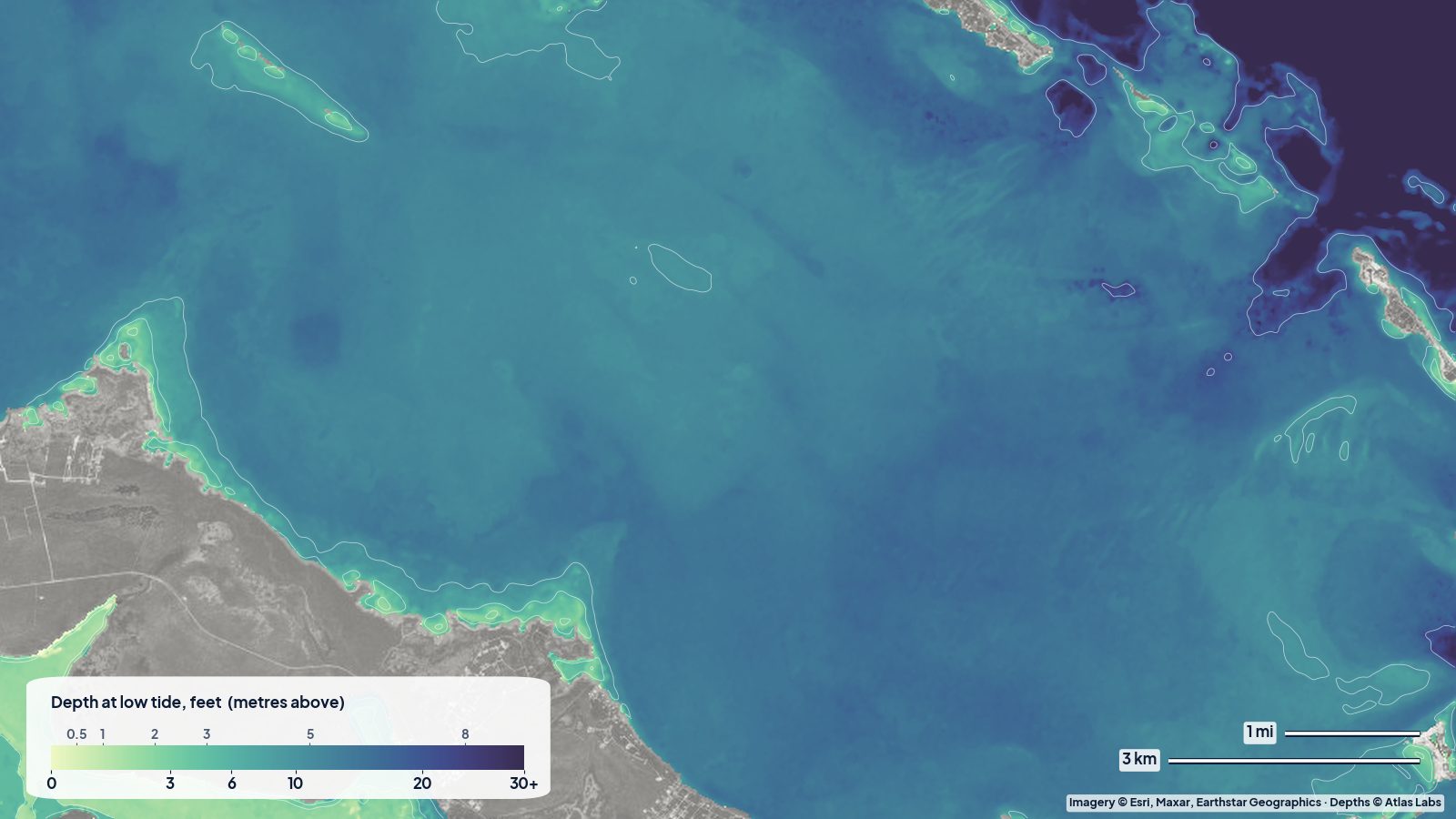
- Open bay away from channels: roughly 4 to 9 ft (1.2 to 2.7 m).
- Featherbed Banks: roughly 1 to 3 ft (0.3 to 0.9 m) across the banks; a well-known grounding spot for sailboats.
- Bay side of Elliott Key: roughly 2 to 6 ft (0.6 to 1.8 m) of grass flats; the Elliott Key harbor is dredged and shallow at the entrance.
- Ocean side of Elliott Key: roughly 5 to 15 ft (1.5 to 4.6 m) over hard bottom, then patch reefs.
Launch points and boat ramps
- Crandon Park Marina (Key Biscayne): large public ramp with trailer parking, close to the sandbar and Stiltsville.
- Hobie Beach / Rickenbacker Causeway: free carry-in launches for kayaks, paddleboards and windsurfers along the causeway.
- Bill Baggs Cape Florida State Park: kayak rentals and a sheltered lagoon; a short paddle to Stiltsville in calm weather.
- Matheson Hammock and Black Point Marina: mainland ramps for skiffs and bay boats with direct access to the central bay.
- Homestead Bayfront Park and Convoy Point (Biscayne National Park): ramps and kayak launches for the southern bay and Elliott Key crossings.
Best tide, wind and season
- Tide: The sandbar is best around high tide if you want to float and around low tide if you want to stand. Stiltsville and the Safety Valve are best paddled near slack; the cuts run hard. Elliott Key crossings are easiest on a rising tide with light wind.
- Wind: The bay is open and shallow, so even 15 knots builds a steep chop. Easterlies make the west shore calm; northerlies flatten the water behind Key Biscayne.
- Season: November to April is the dry season with clear water and busy weekends. Summer is calm in the mornings with storms in the afternoon; July and August bring lobster-season crowds to the southern bay.
Hazards
- Boat traffic and wakes: The northern bay on a weekend is some of the busiest water in Florida. Stay out of channels, cross quickly and wear bright colours.
- Shallow banks: The Safety Valve, Featherbed Banks and the flats off Elliott Key stop boats daily. Seagrass is protected; prop scarring brings fines.
- Current in the cuts: The Safety Valve channels and Bear Cut carry strong tidal flow out to the ocean.
- Crossing to Elliott Key: It is about 7 miles (11 km) of open water from Convoy Point. Only experienced paddlers should attempt it, and only in settled weather.
- Afternoon storms: Summer squalls arrive fast from the Everglades.
Kayak and skiff draft guidance
Kayaks and paddleboards drawing 4 to 6 in (10 to 15 cm) can cover the whole bay; the only obstacles are exposed banks at low spring tide. Paddleboarders love the sandbar and the Stiltsville flats on calm mornings.
Poling skiffs with 6 to 10 in (15 to 25 cm) of draft can work the Safety Valve, the Featherbed Banks edges and the Elliott Key flats on a mid tide. Bay boats and small cruisers drawing 12 to 24 in (30 to 60 cm) should stay in water the map shows as 3 ft (0.9 m) or more and avoid the banks entirely on a falling tide. Sailboats drawing 4 to 6 ft (1.2 to 1.8 m) should keep to marked channels and treat the Featherbed Banks as a wall.
Frequently asked questions
How deep is Biscayne Bay?
On average about 6 ft (1.8 m), with a natural maximum of around 13 ft (4 m) outside dredged channels. Large areas are only 1 to 3 ft (0.3 to 0.9 m) at low tide.
How deep is the water at Stiltsville?
Around the houses the water is commonly described as 3 to 6 ft (0.9 to 1.8 m) at low tide, with shallower banks and deeper channels close by. Check the live map for the exact spot.
Where can I kayak in Biscayne Bay for free?
The Rickenbacker Causeway beaches (Hobie Beach) are the classic free launch. Several mainland parks also allow carry-in launching.
Can I paddle to Elliott Key?
Yes, but it is a long open-water crossing of roughly 7 miles (11 km) from Convoy Point. Pick a calm day, start early and carry a VHF radio.
Is the Nixon sandbar shallow enough to stand?
At low to mid tide most of the sandbar is knee to waist deep. At high tide parts are chest deep or more.
Related reading
Safety note: ShoalScope depth maps are satellite estimates for planning and curiosity only. They are not for navigation. Use official charts, obey channel markers and park rules, and wear a life jacket.