Pine Island Sound is the broad, shallow lagoon between Pine Island and the barrier islands of Sanibel, Captiva, North Captiva and Cayo Costa on Florida’s south-west coast. It is one of the most productive flats-fishing waters in the state and the spine of the Great Calusa Blueway paddling trail. Away from the Intracoastal channel the sound averages only about 4 ft (1.2 m), and huge areas are shallower than that. This guide explains the bottom, typical depths by zone, where to launch, when to go and what to watch for. The satellite depth map for this cell is updated regularly.
What the bottom looks like
- Open sound: broad turtle-grass and sand flats over a firm to soft bottom, crossed by a few natural channels and the dredged Intracoastal Waterway.
- Island edges (Captiva, Buck Key, Cayo Costa): mangrove shorelines with oyster bars at the creek mouths and sand bars that dry at low water.
- Captiva Shoals and the pass sandbars: shifting sand off Redfish Pass, Captiva Pass and Blind Pass; chart descriptions of the Captiva Shoals area show depths from half a foot to 3 or 4 ft (0.15 to 1.2 m).
- The passes themselves: Redfish Pass, Captiva Pass and Boca Grande Pass to the north are deep, fast tidal channels with strong current and heavy boat traffic.
- Gulf beaches: sand shelving gently into the Gulf, with sandbars and troughs along Captiva and Sanibel.
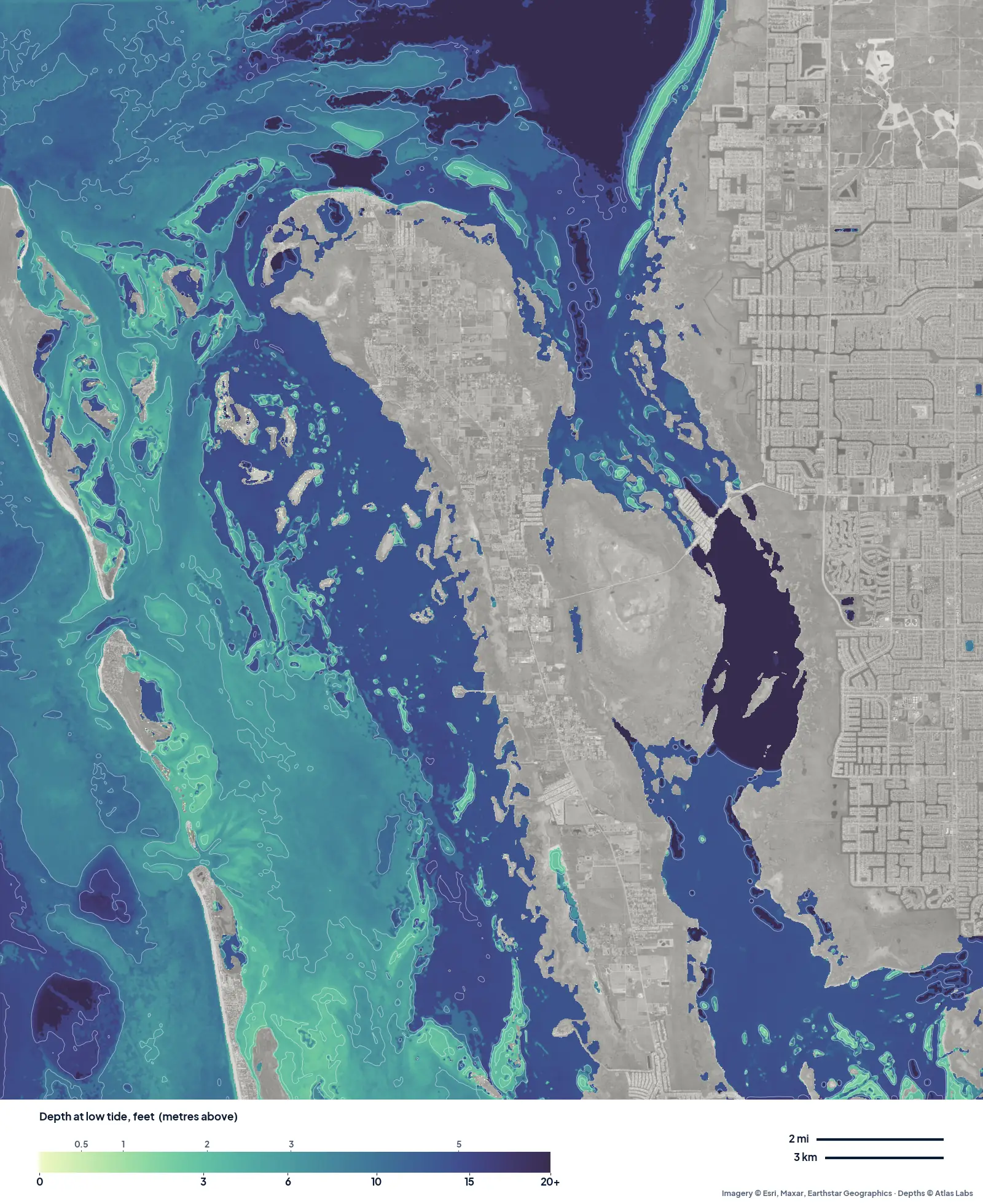
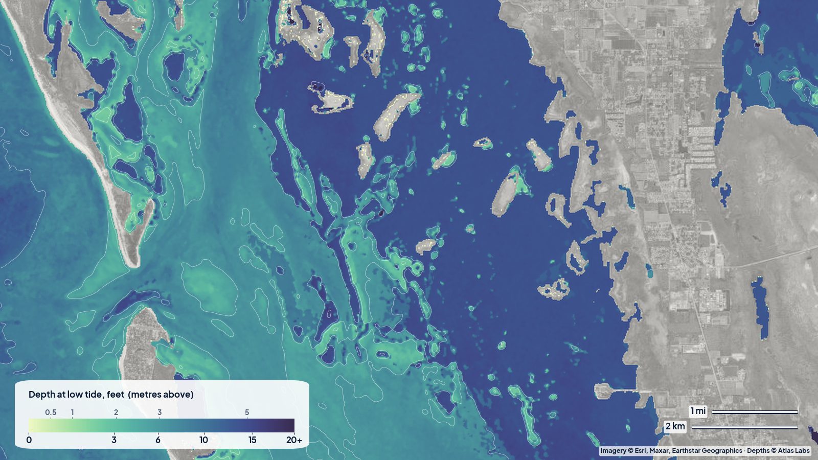
The real depth map of Pine Island Sound at low tide. The pale bands along the islands are the grass flats; the blue lane down the middle of the sound is the deeper water most boats run. Tap any spot on the live map for a number.
Approximate depth by zone
Typical ranges only; sandbars shift after storms and water level depends on wind as much as tide, so check the live map.
- Open sound flats: roughly 2 to 5 ft (0.6 to 1.5 m), with large patches under 2 ft (0.6 m) at low tide.
- Intracoastal channel through the sound: dredged, roughly 7 to 10 ft (2.1 to 3 m).
- Mangrove edges and creek mouths: roughly 1 to 3 ft (0.3 to 0.9 m), oyster bars awash.
- Captiva Shoals and pass sandbars: roughly 0.5 to 4 ft (0.15 to 1.2 m).
- Redfish Pass and Captiva Pass: roughly 10 to 25 ft (3 to 7.6 m) in the throat, shoaling fast at the edges.
- Gulf beach off Captiva: roughly 2 to 8 ft (0.6 to 2.4 m) within the first few hundred feet.
Launch points and boat ramps
- Pineland Marina and the Pine Island ramps: the Pineland side has an accessible kayak launch (fee) and trailer ramps; Matlacha and St James City on Pine Island have more ramps and rentals.
- Bokeelia: launches at the north end of Pine Island with a short paddle to the Blueway islands.
- Captiva: Jensen’s and McCarthy’s marinas, Buck Key launch: kayak rentals and a sheltered paddle through Buck Key’s mangrove trail.
- Sanibel: Tarpon Bay Explorers (Ding Darling refuge): rentals and a launch into the refuge’s protected shallows.
- Cayo Costa State Park: reachable only by boat or ferry; kayak rentals at the dock for exploring the island’s bayside shallows.
- Punta Rassa ramp (Sanibel causeway): large public ramp for skiffs and bay boats.
Best tide, wind and season
- Tide: Fish and paddle the flats on the rising tide; many Blueway segments cross flats that are too shallow to paddle comfortably at low spring tide. Transit the passes near slack.
- Wind: The sound is sheltered from westerlies by the barrier islands and from easterlies by Pine Island, but a strong north or south wind runs straight down its length and builds a steep chop.
- Season: Winter and spring (January to May) are the dry, clear, busy months; tarpon arrive in Boca Grande Pass in May. Summer is hot with afternoon storms and warm, sometimes murky water. Fall is quiet and often excellent.
Hazards
- Grounding on flats and bars: The sound is full of water under 2 ft (0.6 m); the pass sandbars move after every storm.
- Current in the passes: Redfish Pass and Boca Grande Pass carry strong tidal flow and heavy traffic. Paddlers should avoid them on a running tide.
- Oyster bars: Sharp and shallow at creek mouths along Pine Island and Buck Key.
- Boat traffic: The Intracoastal and the marina channels are busy with fast boats, especially on weekends and in tarpon season.
- Red tide and water quality: Episodes occur in some years; check local reports before swimming.
Kayak and skiff draft guidance
Kayaks and paddleboards (4 to 6 in, 10 to 15 cm of draft) can paddle the whole Blueway at mid to high tide; at low tide expect to walk across some flats and to detour around bars.
Poling skiffs drawing 6 to 10 in (15 to 25 cm) are at home on the sound’s flats on a rising tide. Bay boats drawing 12 to 18 in (30 to 45 cm) should keep to the Intracoastal and the natural channels and venture onto flats only where the map shows 3 ft (0.9 m) or more. Allow at least 1 ft (0.3 m) of margin above your draft, more when a northerly is pushing water out.
Frequently asked questions
How deep is Pine Island Sound?
About 4 ft (1.2 m) on average away from the channel, with large flats under 2 ft (0.6 m) at low tide. The dredged Intracoastal is roughly 7 to 10 ft (2.1 to 3 m).
How deep is Redfish Pass?
The throat is deep, roughly 10 to 25 ft (3 to 7.6 m), but sandbars on both sides rise to a foot or two. Current is strong.
Where do I launch a kayak for the Great Calusa Blueway?
Pineland, Bokeelia, Matlacha and St James City on Pine Island, plus Captiva and Sanibel outfitters, all connect to the trail.
Can a bay boat run across Pine Island Sound?
In the Intracoastal and natural channels, yes. Across the open flats only at high tide and with local knowledge or a good depth map.
Is Captiva good for paddleboarding?
Yes. Buck Key’s mangrove trail and the bayside flats are calm on most mornings; the Gulf side is good when the wind is offshore.
Related reading
- Tampa Bay depth map: Fort De Soto and Weedon Island
- Ten Thousand Islands depth map
- Crystal River and Homosassa depth map
Safety note: ShoalScope depth maps are satellite estimates for planning only and are not for navigation. Pass sandbars move after every storm. Use official charts, local knowledge and a life jacket.