Eleuthera is a 110 mile (180 km) long sliver of an island in the central Bahamas, so narrow in places that you can see the deep Atlantic on one side and the shallow Caribbean-facing banks on the other. Off its north-east tip lies Harbour Island, home to the famous pink sand beach, and off its north-west tip the fishing town of Spanish Wells, surrounded by some of the most beautiful sandbars in the Bahamas. Between the two runs the Devil’s Backbone, a reef passage so notorious that yachts hire pilots to get through it. This guide covers the north end of Eleuthera: typical depths by zone, access, tides, and the hazards that have earned the area its reputation. The satellite depth map for this cell is updated regularly.
What the bottom looks like
- Harbour Island’s bay side (west): a shallow bank of white sand and seagrass between Harbour Island and mainland Eleuthera, with a dredged channel to the Dunmore Town docks and marinas, and sandbars that emerge at low tide.
- Pink Sand Beach (east, Atlantic side): a 3 mile (5 km) beach of pale pink coral sand shelving gently into clear water, protected by an offshore reef that breaks the Atlantic swell.
- The Devil’s Backbone: a maze of coral reef and rock between the north coast of Eleuthera and the ocean, through which a narrow, unmarked channel winds from Spanish Wells to Harbour Island; the reef is often within a few feet of the surface.
- Spanish Wells and the sandbars: a tidy harbour town on St George’s Cay with miles of sandbars and shallow banks to its south and west, the kind that go from ankle deep to dry as the tide falls.
- Current Cut: a narrow pass between North Eleuthera and Current Island where the tide runs at several knots, famous for drift snorkeling.
- The Caribbean-side bays (Gregory Town, Governor’s Harbour and south): sheltered bays with sand and seagrass that shelve gently, the island’s easiest paddling.
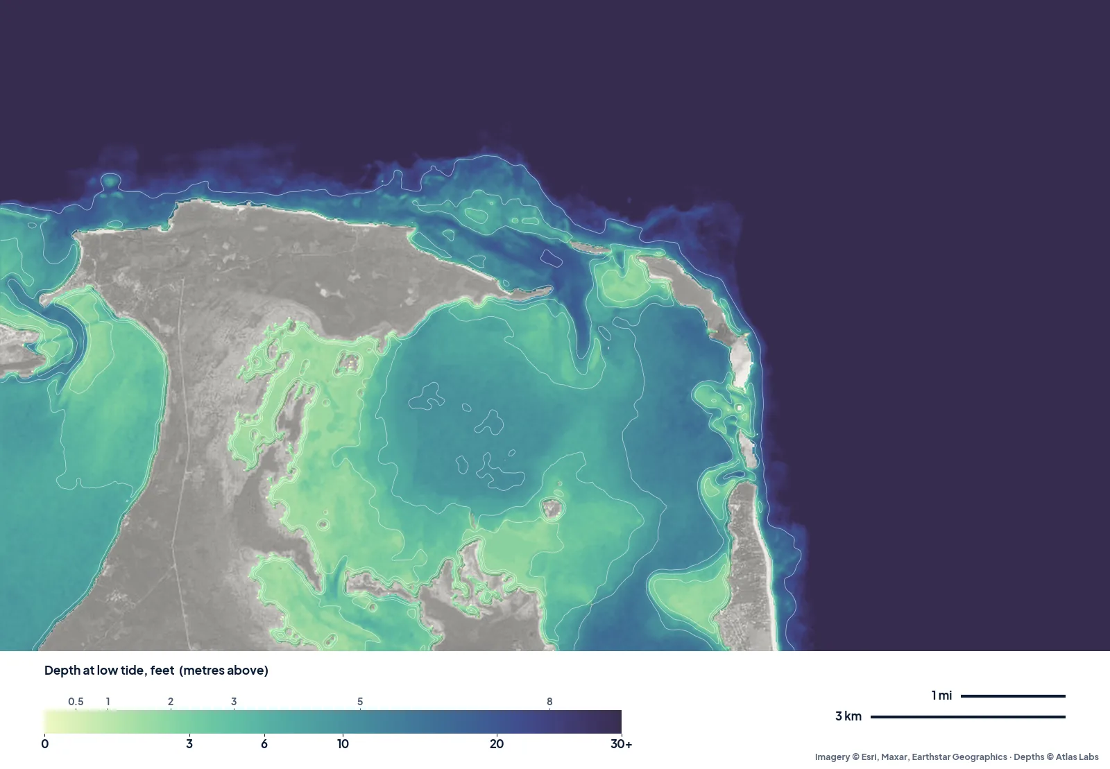
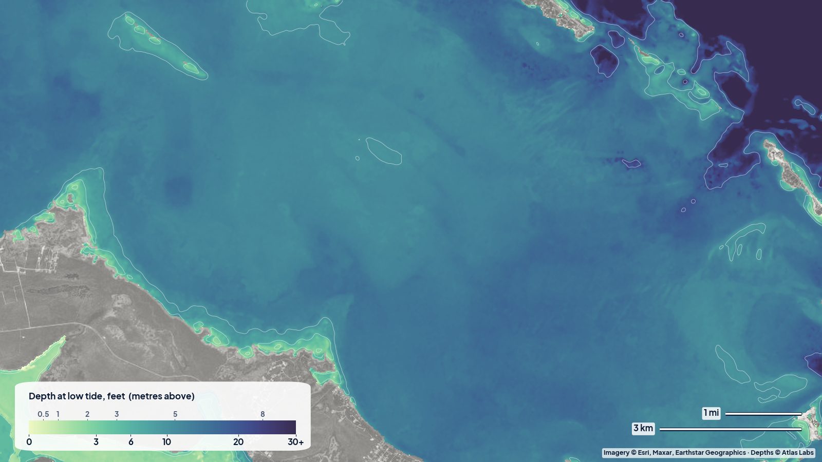
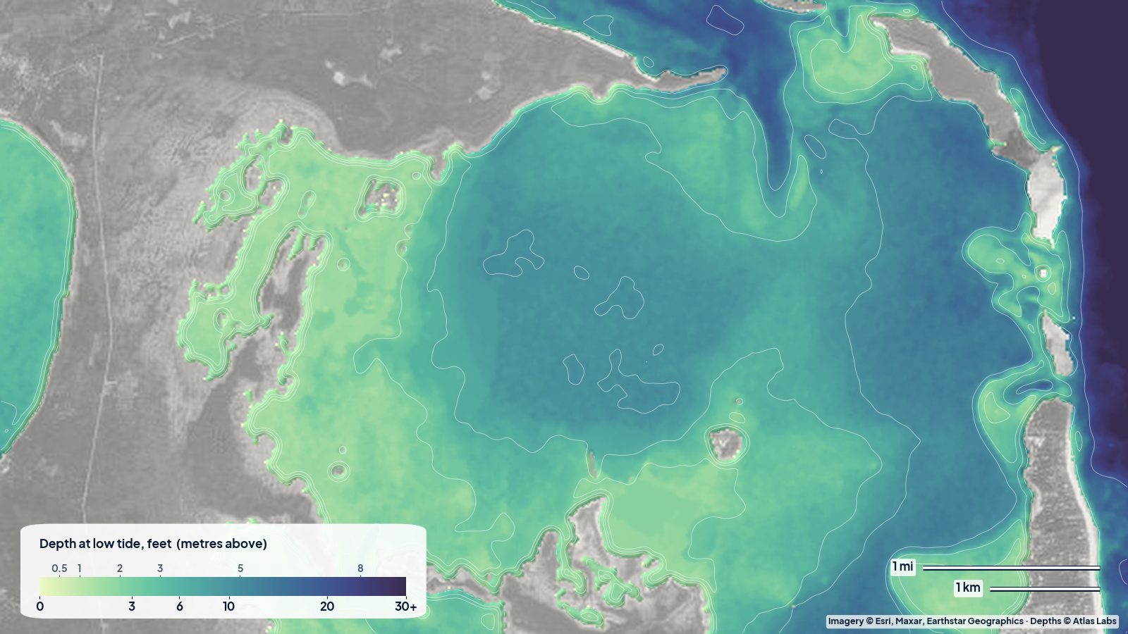
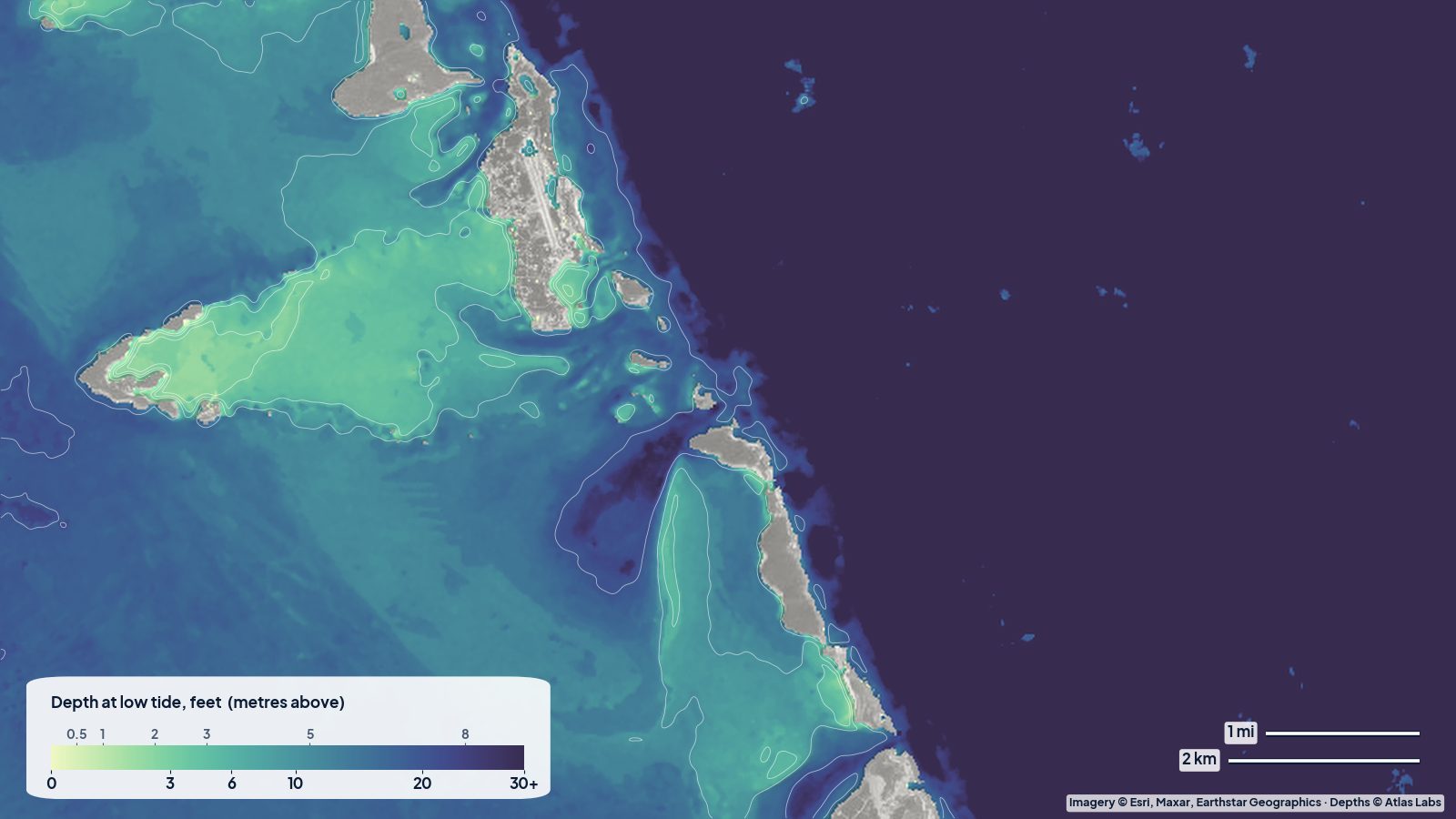
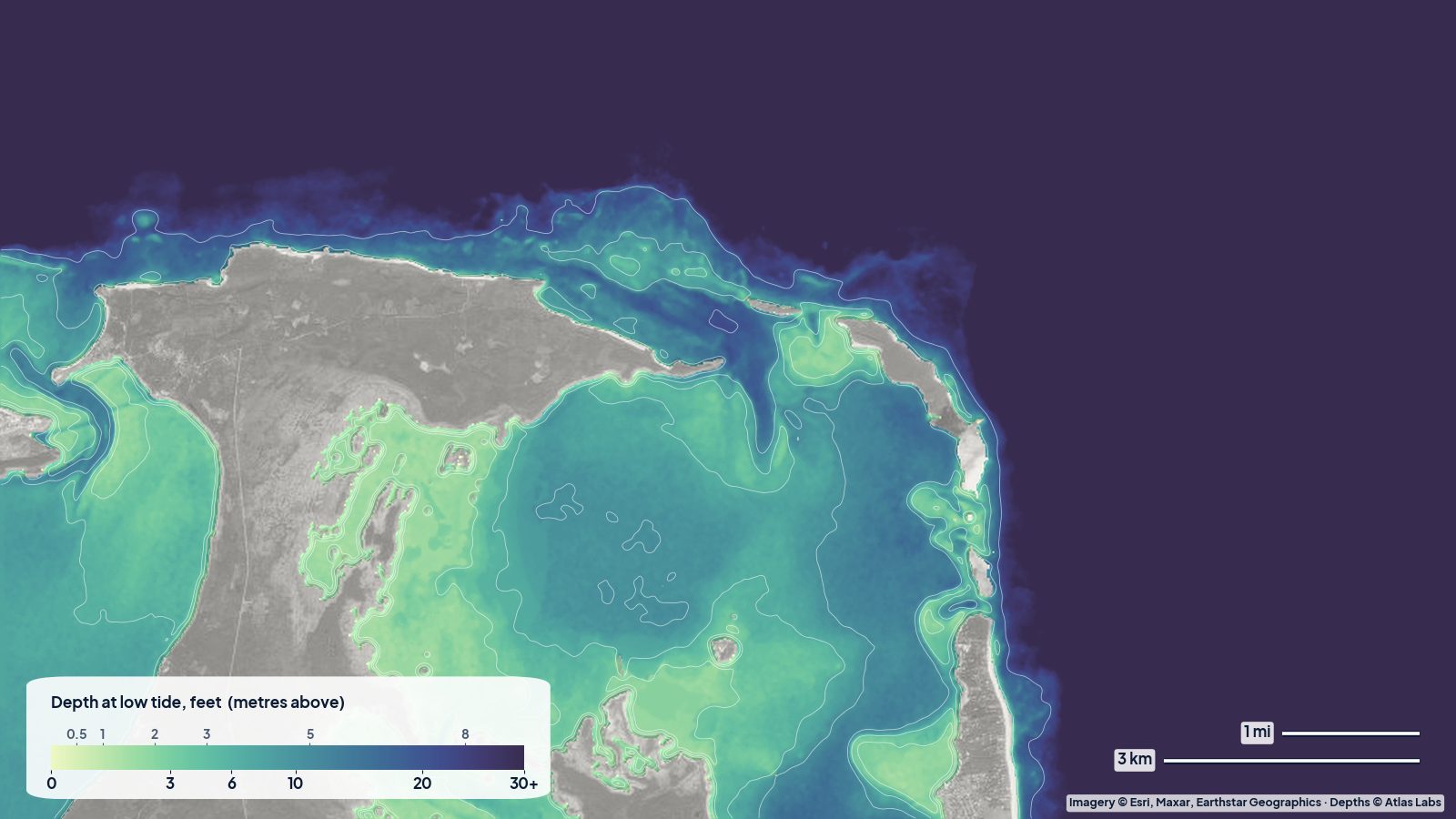
The real depth map of North Eleuthera and Harbour Island at low tide. The narrow shelf along the north shore is the Devil’s Backbone reef line; inside, the bay toward Harbour Island mixes pale sand flats with a deeper basin. Tap any spot on the live map for a number.
Approximate depth by zone
Typical ranges only. The tide range is roughly 2.5 to 3.5 ft (0.8 to 1.1 m), which exposes and covers the sandbars every day. Check the live map and the tide together.
- Harbour Island bay side, away from the channel: roughly 2 to 8 ft (0.6 to 2.4 m), with sandbars drying at low tide.
- Dunmore Town channel and marinas: dredged, roughly 7 to 10 ft (2.1 to 3 m).
- Pink Sand Beach swimming area: roughly 2 to 10 ft (0.6 to 3 m) within the first 50 yards, sand bottom; the protecting reef is roughly 10 to 25 ft (3 to 7.6 m) with coral to the surface.
- Devil’s Backbone channel: roughly 8 to 15 ft (2.4 to 4.6 m) in the channel itself, with reef within a few feet of the surface on both sides.
- Spanish Wells sandbars: dry to 2 ft (0 to 0.6 m) at low tide; local descriptions say the water is no more than ankle deep on the best bars.
- Current Cut: roughly 15 to 40 ft (4.6 to 12 m) with currents of 3 to 6 knots.
- Caribbean-side bays: roughly 2 to 15 ft (0.6 to 4.6 m), gentle slope.
Access, launches and anchorages
- Harbour Island: reached by a short water taxi from the North Eleuthera ferry dock; marinas and moorings in Dunmore Town, golf carts for getting around, kayak and paddleboard rentals at the resorts.
- Spanish Wells: reached by water taxi from Gene’s Bay or by yacht via the Devil’s Backbone (with a pilot) or the deeper routes from the south-west; a working harbour with marinas, fuel and local sandbar boat tours.
- North Eleuthera: the airport and the ferry docks; small boats launch at the government docks and local ramps.
- Governor’s Harbour and the Caribbean-side settlements: docks and beach launches for kayaks along the sheltered west coast.
- Pilots for the Devil’s Backbone: local pilots board at Spanish Wells or Harbour Island and guide yachts through; most charter and insurance agreements require it.
Best tide, wind and season
- Tide: Visit the sandbars an hour either side of low tide for walking and wading; paddle the Harbour Island bank at mid to high tide. Current Cut is snorkeled on a strong incoming tide with a boat following. The Devil’s Backbone is run only in good light, settled seas and ideally a rising tide.
- Wind: The trade wind from the east and south-east makes the bay side of Harbour Island and the Caribbean-side bays calm and the Atlantic beaches lively; a north swell in winter closes the Devil’s Backbone and churns Pink Sand Beach.
- Season: December to April is the busy, pleasant season; summer is hotter and quieter with the clearest water; hurricane season peaks August to October.
Hazards
- The Devil’s Backbone: Unmarked, winding and unforgiving, with reef at the surface on both sides. Hire a pilot. Do not attempt it at night, in swell or with the sun in your eyes.
- Current Cut: Several knots of current; only for strong swimmers with a chase boat.
- Sandbars drying under you: Kayaks and dinghies get stranded on the Spanish Wells and Harbour Island banks as the tide falls; plan the return.
- Boat and water-taxi traffic: The Harbour Island and Spanish Wells channels are busy.
- Reef and urchins: On the Atlantic side; wear reef shoes near rocks.
- Sun and no shade: Carry water on the sandbars.
Kayak and boat draft guidance
Kayaks and paddleboards (4 to 6 in, 10 to 15 cm of draft) are perfect for the Harbour Island bank, the Spanish Wells sandbars and the Caribbean-side bays, all sheltered in trade winds. Avoid the Devil’s Backbone and Current Cut.
Yachts drawing 4 to 7 ft (1.2 to 2.1 m) reach Harbour Island and Spanish Wells via the piloted Devil’s Backbone or the longer routes around the banks, and should enter the marinas at mid to high tide. Skiffs and dinghies drawing 6 to 18 in (15 to 45 cm) can run the banks and visit the sandbars but must watch the falling tide. Allow at least 1 ft (0.3 m) above your draft, more on the banks.
Frequently asked questions
How deep is the water at Pink Sand Beach?
Roughly 2 to 10 ft (0.6 to 3 m) in the swimming area close to shore, over sand, with a protecting reef further out. Swell varies by season.
Where are the sandbars near Harbour Island and Spanish Wells?
On the bank between Harbour Island and mainland Eleuthera and across the shallows south and west of Spanish Wells, exposed an hour either side of low tide.
How deep is the Devil’s Backbone?
The channel itself holds roughly 8 to 15 ft (2.4 to 4.6 m), but reef lies within a few feet of the surface on both sides and the route is unmarked. Hire a local pilot.
Can I kayak at Harbour Island?
Yes, the bay side is calm and shallow and rentals are available. Stay away from the channel traffic and watch the tide on the bank.
Is Current Cut safe to snorkel?
Only on a guided drift with a chase boat on an incoming tide. The current runs several knots.
Related reading
- Exumas and Staniel Cay depth map
- Abacos and Sea of Abaco depth map
- Grace Bay, Turks and Caicos depth map
Safety note: ShoalScope depth maps are satellite estimates for planning only and are not for navigation. The Devil’s Backbone and Current Cut are genuinely dangerous. Use official charts, a local pilot and good light, and wear a life jacket.